Monday, February 20, 2012

Submerged urbanization: The World's Underwater Cities


     I love underwater archaeology and oceanography.  I think that the deep sea is the last frontier that we will get to explore.  It is much more exciting to me than outer space.  

     With over 70% of the earth's surface covered by water, we have successfully explored only one to two percent of the floor of the ocean. Every time someone goes down there, they wind up finding something new, whether unknown sea creatures, unknown geological features on the ocean floor or something from the world of man.  
Ships.  
Artifacts.
Cities.

Cities?!!

     Scientists tell us that over 10 MILLION SQUARE MILES ( that's the size of China and Europe combined) of land, all previously above water, is now underwater.  Is it any real wonder that we would find submerged cities?  The areas that we now call the continental shelves (comparatively shallow areas that surround the continents, in some cases for several hundred miles), the Mediterranean and the Black Sea were all dry land at one point.  

     The Mediterranean is one of the shallower seas and has been the site of a great deal of archaeological, professional and sport diving and exploration.  Over 200 cities have been located on the bottom of the Mediterranean.  They're not just around the shorelines, either, where they could have fallen off the coast as the result of erosion.  They are distributed all across the seabed, at varying depths.

      Not surprisingly, the Darwinian academics are not in the least interested in investigating these cities.  Their historical investigations are confined strictly to sunken ships and the like. 
    That's to be expected.  Cities at the bottom of the sea would be too hard to explain and would disrupt  the fairy tale that they call "the scientific reconstruction of history."

      Let's look at the Americas. 

     Some commercial oceanographers were working for the Cuban government in the sea region between the far western tip of Cuba and the Yucatan peninsula, off what the Cubans call the Guanahacabibes peninsula.


Side scan sonar image taken off the coast of Cuba

     While mapping the sea floor in that area with side scan sonar (which is apparently a really cool technology, because they keep finding all kinds of things with it), the scientists started getting indications of straight lines and regular features - about a half a mile below the surface of the water (2,200 feet).

      Divers can't operate at such crushing depths, so they sent down remotely operated submersible vehicles (R.O.V.'s).  These are little robots that can move around like little submarines, equipped with lights and cameras that can send images to a ship on the surface.


Artist's rendition of the Guanahacabibes site

     What they found were huge constructions of megalithic sized stones, some 40 to 50 tons, stacked one atop the other.  There were right angles and corners and straight lines and smooth curves that don't exist without the hand of man being involved - at least not all together, over and over again. 

Guanahacabibes again
     After a great deal of detailed scanning and mapping, the explorers have located some 30 structures with broad avenues between them.  As you can tell by their reconstructions, the site looks very much like the Mesoamerican cities that we see all over Mexico and the Yucatan, built by the Mayans, the Aztec, the Toltec and other peoples.

Guanahacabibes once more
     You can see in the oceanographers' illustrations all the architectural features that we recognize from places with ancient names like Chichen Itza or Teotihuacan or Palenque.  There are the blocky buildings stepping progressively higher to huge display combs at the rear. There are the uniquely tall, thin pyramids and the broad, open plazas.  

     Obviously, they are constructions that are linked to the buildings and structures that we see in so many of the ruined Native American cities of Central America, but they are a half a mile below the sea.  There are no records or legends in any of the Native American cultures that speak of any such city, so this was apparently a place that was submerged in the ocean long before the memory of any of the peoples we know - and their records and stories go back thousands of years.


A side scan sonar image from the sea floor off the Gulf of Khambhat.

     The nation of India has also had some exciting finds.   In 2001, the Indian Oceanic Institute was doing oceanographic surveys in the Gulf of Khambhat to study the effects pollution may be having on the ocean environment there.

Another sonar image


     Seven miles off shore, while scanning the sea floor with (again!) side scan sonar, at a depth of 170 feet, they started picking up images that were both regular and repetitive - straight lines forming grids.  It was something significant, because it covered five square miles of the sea floor.


     The Indian government immediately dispatched exploratory and survey teams to investigate.  Underwater work at the site is very difficult and dangerous for divers, because there are very powerful cross currents in that region.

     Even so, they were able to locate many of the features that had produced the grid shaped images on their sonar screens. Long stone walls are clearly visible on the sea floor, obviously made of cut, shaped and stacked stones.

     Two distinct cities were located, both situated on the banks of a former riverbed.  The cities were both large and well-formed.  The grid maps of their streets are reminiscent of Mohenjo-Daro, Harrapa and the other cities of the Indus Valley culture (which we have discussed in the first blog entry).


     Even more exciting, they have been able to bring up dozens of artifacts and evidences of human habitation. Objects of stone, pottery, metal and wood have been retrieved. There have even been fragments of bone found.


     Western scholars tend to routinely dismiss Indian culture and history as subordinate to, and derivative from, other cultures. They say that the Indian people migrated to India from the Middle East. They even call them Indo-Europeans.  Indian tradition and history, however, portrays a long and rich history, thousands of years old. Indian scholars were called in to analyze the information available on the new Khambat Gulf sites and that analysis is still in process.


An artist's reconstruction of Dwaraka
     About 200 miles north the Khambat Gulf site, lies the current living city of Dwarka or Dwaraka.  Excavations under the city uncovered traces of a far more ancient city that had been underwater at one time.  
     Carrying the search into the sea, divers found ruins just off-shore, in only seventy feet of water.  Indian scholars determined that this was very likely the ancient city of Dwaraka, which the ancient Sanskrit writings said was a large and powerful city that fell when it was covered by the sea.  Dwaraka figures prominently in many ancient Hindu stories, so this was very exciting to the Indian people.  For perspective, imagine our excitement, in the Christian culture, if the Garden of Eden or Noah's Ark were found! 


     In addition, a short way further north, near the city of Shrivardhan, a wall that was obviously constructed by human hands has been found on the sea floor.  It is 1.18 kilometers long.  That's about 7/10's of a mile - say seven city blocks long.

     It is interesting to note that Indian stories clearly describe dry land (whole countries, in fact) stretching out for many miles into the regions that are now called the Arabian and Indian Seas.


The main islands of Japan are in the 1 o'clock position on this map.  Taiwan is at 8 o'clock.

     If we turn our eyes further east to the Pacific, you can see a small island that is on the very southern tip of the Japanese archipelago or island chain. 
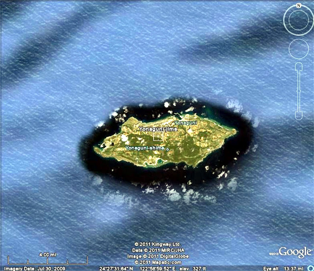
Yonaguni Island
     The small island, which almost touches the island of Taiwan or Formosa, is called Yonaguni.  Yonaguni is well known to have many stone constructions on the island itself - constructions that are very old, made by an unknown people.

     In 1987, Kihachiro Aratake, a man who owns a sport diving business on Yonaguni, was searching for new and interesting sites to take his clients. 


     He found in 70 to 100 feet of water a huge, complex structure made of stone, the size of two football fields.  Other divers and scientists by the hundreds have since scoured the site.

     While the stone of the structure is known in the area and does naturally form in rectangular layers or crystals, this was much more than some naturally occurring formation.

   There are perfectly rectangular lanes, tunnels and passages with steps at the end.


     There are triangular structures that cut diagonally across the "grain" of the stone.


     There is one place where two megalithic pillars have been placed side by side, in a manner that is far too regular to say that they just fell there. 


     And then, there are the faces carved into the stone, some of them 23 feet tall.


     The divers above are floating in front of a large carved face.  Its eyes are beside the middle diver's head and are looking to your left.  The mouth is between the two divers'
hips.  The face is looking to your left and is sporting
a sweeping headdress that swoops to your right and down (somewhat like an Native American war bonnet).

Tell me these are just holes in the rock that just eroded that way by chance
and not artfully carved human eyes.


     Besides the faces, carvings have been found on the rock, depicting turtles, fish, boats, the sun and other less interpretable images.  The chart to the right records many of the carvings. 

     After the first find, about a half-dozen other sites have been found nearby that are obviously related, but none are as large and complicated as the first one.  In addition to all this, explorers and scientists have found numerous human tools and artifacts. 


     In a side note, it is recorded that Ashurbanipal (668 – c. 627 BC), an Assyrian king, was known for having gathered a copy of every known text from his time into his library.  He left records boasting that he could read writings from before the flood, and describes cities and civilizations that existed before the deluge, but which were wiped out by that flood.  

     What else is under the sea that we need to know about?  Let's all learn to scuba and find out, because I seriously doubt that the universities and museums will ever tell us.


WARNING!!


This blog has been written with the sole purpose of using the ample evidence available to verify and support the biblical record, while refuting the copious propaganda that is shoved down our throats daily by materialistic uniformitarians.


It is my contention that the Bible describes God's original creation of people with extraordinary capabilities who subsequently built an advanced civilization that exceeds our own. That civilization was destroyed in the Great Flood and we have spent the last 5,000 years trying to re-build that civilization. I contend that science supports all this in multiple disciplines, but this information is ignored or suppressed by various people who have an opposing agenda.


Nothing that you see on this blog is original. Any fact that you see here is obtainable on a dozen different websites and books. I use these facts and photos, without violating their copyrights, under the legal principle of fair use practice. That is, I use them one time, for educational purposes only.


The point is, nothing here is made up. The only thing that I do (or need to do) is assemble this information in a discernible pattern.


You might want to read through the first entry posted on this blog (Past Remembering: Thoughts toward a coherent view of our ancient past, our present and our future) in order to understand my theoretical and theological underpinnings more clearly.


The truth is there. You just have to see it.
  

 Ecclesiastes 1:9-10 (NASB)

That which has been is that which will be,

And that which has been done is that which will be done.

So there is nothing new under the sun.

Is there anything of which one might say,

“See this, it is new”?

Already it has existed for ages

Which were before us.


Thursday, February 9, 2012

Ollantaytambo: The possibly impossible in Peru


      To the southeast of Lima, Peru, in the mountains of the Andes, lies the picturesque little mountain valley of Ollantaytambo.
     It has a picturesque little village filled with colorful local people.


     As with most of the areas of the Andes that are inhabited, this town has many examples of the fantastic stonework of the Kilke people, the predecessors of the Inca, both in the town......

...and surrounding it....


 ....and surrounding it some more.  


     One of the most significant examples of this work is a site called "The Wall of Six." 
     As you can see, it is typical of other Kilke works.  Irregular stones are mated together with such meticulous precision that there are literally NO gaps.  There is no place in any of the joints that you can insert a knife blade or even a piece of tissue paper.     The individual stones are megalithic in size, the smallest weighing several tons.


      We can easily see where they were carved from the rock face on the other side of the valley.  Several questions arise from even a cursory examination, though.  The cut marks are perfectly square.  You would think that the stone would be knocked out of the rock face and then squared.  That is how modern stone cutters would do it.  Not so here.


     Secondly, the surface of the cuts are glassy smooth, not rough the way you would expect sawn or chiseled surfaces to be.
     
Then, there is the height.  Why did they cut the rocks from a places that are sometimes 130 feet above the floor of the valley?  How did they get them down?  While there are some stairways (below) cut into the rock face to allow people to walk up to the quarry site,  there are no evidences of ramps or even skid tracks that could have carried the megaliths.  If the stones were allowed to drop to the valley floor, they would have surely shattered. 

     Lastly, how were they transported from one side of the valley to the other?  The quarry site is miles from, for instance, the site of the Wall of Six.  Nowhere in the valley is there any sign of any sort of road that could have been used to transport multi-ton loads.  The little river that runs through the floor of the valley and the middle of the town has cut a very deep channel that is unbroken by any shallow fords. Where did the builders of the Wall of Six cross such a deep channel?  

     No evidence of such a place exists.  

     Hmmm.


WARNING!!


This blog has been written with the sole purpose of using the ample evidence available to verify and support the biblical record, while refuting the copious propaganda that is shoved down our throats daily by materialistic uniformitarians.


It is my contention that the Bible describes God's original creation of people with extraordinary capabilities who subsequently built an advanced civilization that exceeds our own. That civilization was destroyed in the Great Flood and we have spent the last 5,000 years trying to re-build that civilization. I contend that science supports all this in multiple disciplines, but this information is ignored or suppressed by various people who have an opposing agenda.
Nothing that you see on this blog is original. Any fact that you see here is obtainable on a dozen different websites and books. I use these facts and photos, without violating their copyrights, under the legal principle of fair use practice. That is, I use them one time, for educational purposes only.
The point is, nothing here is made up. The only thing that I do (or need to do) is assemble this information in a discernible pattern. 

You might want to read through the first entry posted on this blog (Past Remembering: Thoughts toward a coherent view of our ancient past, our present and our future) in order to understand my theoretical and theological underpinnings more clearly.
The truth is there. You just have to see it.


Ecclesiastes 1:9-10 (New American Standard Bible)

That which has been is that which will be,

And that which has been done is that which will be done.

So there is nothing new under the sun.

Is there anything of which one might say,

“See this, it is new”?

Already it has existed for ages

Which were before us.


Wednesday, February 1, 2012

The Babylonian Sirrush - Here be dragons...


 Babylon (yes, the same Babylon mentioned in the Old Testament so many times) lies in ruins about 55 miles south of the modern city of Baghdad, Iraq.  If one were to visit the ancient city of Babylon, capital of the Babylonian Empire, during its days of greatness, there would have been many things to see. Babylon was the premiere city in its time for its military, its architecture and its learning. 


One of the first things that a visitor in ancient times might have been shown was the gigantic and beautiful Ishtar, or Blue, Gate. This was the gateway leading to the large processional way, a giant thoroughfare leading to the many temples that filled a large portion of the city.


Modern reconstructions of the Blue Gate
The Blue Gate was blue because it had been covered with tiles glazed with a blue ceramic. Remarkably, their polish was so hard that you can still see the beauty of the actual gate today.  Reconstructions were easy to make, since the details of the gate are still clearly visible.
 
On the gate were many illustrations, created by molding the surfaces of the bricks themselves.  They were meant to depict symbols of power, to intimidate outsiders and subjects alike.  Note in the pictures the exquisite detail of each of the images and the skill that made the images so life-like and of extremely realistic proportions.
There were soldiers, imposing with their arms and beautiful robes.

There were images of bulls, a symbol of strength, virility and brute force in almost every culture, not just the Babylonians.


Lions were, of course, well represented, since they were the symbol of Babylon and the ultimate image of regal strength and intimidation.


Note the great detail and realism lavished on each image.


Sirrush
What is this doing here, then?  It is something the Babylonians called a "sirrush."  An equal amount of detail and realism has gone into its depiction.
"A mythological creature," you say?  None of the other images are mythological.  The Babylonians wanted to intimidate people.  People are more intimidated by real things than by fairy tales. 
The image of the sirrush was very common in the Babylonian culture and was carved and drawn repeatedly.  It is routinely depicted as a frightening and terrible beast.


Notice in this drawing that the sirrush was approximately the size of a man. 


Also notice in this close up of the same drawing, that the forepaw or "hand" of the sirrush has a distinctively long thumb and claw.


Now, meet Massospondylus, a creature whose remains have been found in great quantities, indicating that it was a very common species.   This drawing was constructed from the fossilized bones that have been found.

 
Massospondylus was about the size of human being or a little larger, as this chart illustrates.


       Massospondylus has a large claw on the "thumb" of each "hand," just like the sirrush did.  Note the representation here.

What about the horns and frills in the drawings of the sirrush?  Horns and frills are mostly soft tissue, like skin and flesh.  They rarely survive in the fossil record.
The Darwinistic evolutionists insist that dinosaurs lived millions of years before man-kind, with no possibility of contact between the two.  The evidence seems to indicate otherwise.
And there is more.....

     "You shall know the truth..."


WARNING!!


This blog has been written with the sole purpose of using the ample evidence available to verify and support the biblical record, while refuting the copious propaganda that is shoved down our throats daily by materialistic uniformitarians.


It is my contention that the Bible describes God's original creation of people with extraordinary capabilities who subsequently built an advanced civilization that exceeds our own. That civilization was destroyed in the Great Flood and we have spent the last 5,000 years trying to re-build that civilization. I contend that science supports all this in multiple disciplines, but this information is ignored or suppressed by various people who have an opposing agenda.

Nothing that you see on this blog is original. Any fact that you see here is obtainable on a dozen different websites and books. I use these facts and photos, without violating their copyrights, under the legal principle of fair use practice. That is, I use them one time, for educational purposes only.

The point is, nothing here is made up. The only thing that I do (or need to do) is assemble this information in a discernible pattern.

You might want to read through the first entry posted on this blog (Past Remembering: Thoughts toward a coherent view of our ancient past, our present and our future) in order to understand my theoretical and theological underpinnings more clearly.

The truth is there. You just have to see it.


Ecclesiastes 1:9-10 (NASB)

That which has been is that which will be,
And that which has been done is that which will be done.

So there is nothing new under the sun.

Is there anything of which one might say,

“See this, it is new”?

Already it has existed for ages

Which were before us.


Sunday, January 29, 2012

Ancient agriculture

The Andes

     In the majestic highlands of Peru lies the charming town of Huatu. It is a village centered around farming, but it has not done well in the past. Because of the high altitude, the growing season is normally short and the area is subject to unexpected killing frosts at the beginning and the end of the growing season.

The village of Huatu
That means that the crops are just as likely to fail as they are to produce.  Traditional farming methods and Western agricultural experts have been of little or no help.  That has made life very hard for the farmers that make up most of the population of Huatu, with little hope in sight. 

     Then an archaeologist came to Huatu.  He noticed that much of the surrounding countryside was covered with ditches, separated by raised mounds. 

     The native people of Huatu had lost all of their people's past history when the Spanish had conquered the area and wiped out most of their population. They had no idea about why the alternating ditches and mounds were there.  They only knew that they had always been there. 

     The archaeologist spent some time studying the area and he began to have an idea.  He went to some of the local farmers and told them that he had uncovered the meaning of the ditches and that he could teach them how to farm as their ancestors had done.

     As with most of the native peoples of the Andean mountains, the villagers had a great deal of reverence for the people who had come before them.  So the archaeologist was able to convince a few of the farmers to work with him for one season.

     His idea was that the ditches had once held water, making a canal between each of the raised beds.  He worked with the farmers to take one section of the fields and dig the ditches out, putting the soil on the raised mounds in between and then to flood the ditches with water.

     It worked!  The result was that the water held the heat that it collected from the sun every day and then released it as vapor during the night, providing a micro-climate around the crops that was several degrees higher in temperature.  That meant that the crops survived the frosts almost routinely.

     This meant several things.  The farmers could not only successfully raise the crops they had been used before, but they could now expand and raise other types of crops that they had never been able to raise before.  This was, of course, an immediate boost to their income and also lent predictability to their economy.

A Western experimental aquaculture system.
     In addition, the people were able to raise fish in the canals beside each bed.  This gave them yet another rich source of food.  In addition, the fish would feed on the insects that tried to reach the crops, along with the water providing a natural pest barrier.  

     Periodically, the farmers would dig the canals out again, putting the mud on the growing beds.  This was a natural source of fertilizer, since the mud was full of fish manure and offal. 

     All these things together resulted in a self-sustaining system that had been engineered by people thousands of years ago, without the benefit of Western agricultural science.  Indeed, it was far ahead of Western science.

Diagram of a modern aquaculture growing system.
     Modern agriculture has just begun experimenting with aquaculturally based systems and they are usually very small.  As you can see from the diagrams, the fish are kept in a tank.  An electric pump has to push water from the fish tank, laden with waste, up to the growing beds.  The beds filter out the wastes, which fertilizes the crops in the beds and purifies and aerates the water for the fish. 

     Of necessity, this can only be done on a small scale and requires a lot of electricity.  The Huatu system, on the other hand, is self-sustaining and self-balancing and requires no inputs of electricity, fertilizer or pesticide.  It is huge, operating on a landscape sized basis and functions well in an agriculturally difficult climate.

      And it was designed by people who lived thousands of years ago without any knowledge of Western type science.


Aerial view of Moray, Peru
      Then there are the people of Moray, Peru.  They have a different problem.  They have no large dependable source of water to use for their crops, as the Huatu people had, but they also live at a high altitude that makes it difficult to sustain crops.


For perspective, notice the four people standing in
 the circle's center.
     Someone long before them has employed a different strategy.  The large circles that you see on the aerial view photographs are gigantic holes that have been dug into the ground.  Around the edges of the holes, terraces, bordered by stone walls and with steps inset within them for easy access to each level, have been dug, each one about four of five feet lower than the next, making about 15 to 20 different layers.  The lower you go, the more protected the crops are from the high Andean cold and wind, making the micro climates of each level several degrees different from the one below or above it.

     Consequently, the people of Moray can raise about 66 different varieties of crops and vegetables that cannot be raised anywhere else for hundreds of miles.  An added benefit is that the holes provide the perfect amphitheater for special events.  Someone standing in the center of the hole can speak to people standing all around on the terraces and be heard perfectly, without amplification.

 
     Again, so well designed is the system that it is completely self-sustaining, so that the poor, uneducated inheritors of this technology have only to use it.  They don't have to understand it.  It just works by the nature of what it is.

Notice the different crops on each level.


Built in steps to reach each level.

     Lastly, there are the people who live in the Llanos de Moxos area of Bolivia.  They are faced with a completely different agricultural challenge - water management.  

     Unlike Moray and Huatu, they live in a low-land savannah.  Their fields are routinely inundated by deep floods or parched during the dry seasons. 

     However, far in the past, someone of great technical skill landscaped almost the entire region with a system of ditches and raised growing beds that not only keeps the crops dry enough to grow by channeling the flood waters away.  The canals are also linked to large reservoirs that keep enough water in them to keep the canals full during the dry season, watering the crops when they would otherwise die.  At the ends of certain of the growing beds are raised platforms where the farmers used to have their dwellings and storehouses, to be near their fields.

     Again, the native people have no idea of who exactly built these landscape sized agricultural systems, meaning that it happened so far in the past - before they got there - that they don't even have any stories about them.  It is impossible to date.  The only way that all of the fields can be located is by seeing them from the air.  The locals don't even know where they all are. 

     Three completely different agricultural settings with unique challenges that have all been met by technical skill and a level of organization that modern civilization can barely envision, much less reproduce.

     Yeah, the ancient human beings were far inferior to modern people, just like the Darwinists say.

 
WARNING!!

This blog has been written with the sole purpose of using the ample evidence available to verify and support the biblical record, while refuting the copious propaganda that is shoved down our throats daily by materialistic uniformitarians.

It is my contention that the Bible describes God's original creation of people with extraordinary capabilities who subsequently built an advanced civilization that exceeds our own. That civilization was destroyed in the Great Flood and we have spent the last 5,000 years trying to re-build that civilization. I contend that science supports all this in multiple disciplines, but this information is ignored or suppressed by various people who have an opposing agenda.

Nothing that you see on this blog is original. Any fact that you see here is obtainable on a dozen different websites and books. I use these facts and photos, without violating their copyrights, under the legal principle of fair use practice. That is, I use them one time, for educational purposes only.

The point is, nothing here is made up. The only thing that I do (or need to do) is assemble this information in a discernible pattern.

You might want to read through the first entry posted on this blog (Past Remembering: Thoughts toward a coherent view of our ancient past, our present and our future) in order to understand my theoretical and theological underpinnings more clearly.


The truth is there. You just have to see it.


Ecclesiastes 1:9-10 (New American Standard Bible)

That which has been is that which will be,

And that which has been done is that which will be done.

So there is nothing new under the sun.

Is there anything of which one might say,

“See this, it is new”?

Already it has existed for ages

Which were before us.